Skip to content

Program Updates

September 2024 Program Status Update

Monthly Highlight: Newly published article about ephemeral data

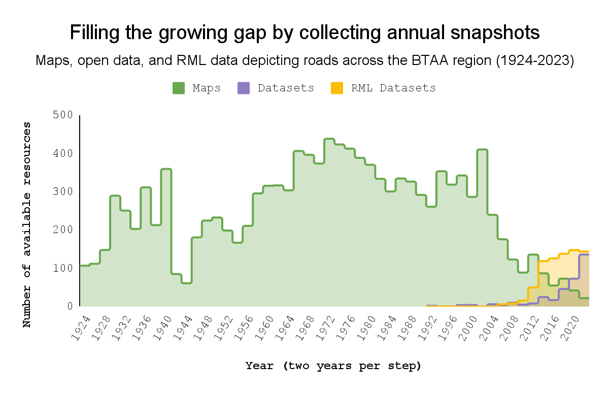
Bar chart of maps and dataset over time

A new article titled "Ephemeral Geodata: An Impending Digital Dark Age," co-authored by four BTAA-GIN Team Members, was recently published in the Journal of Map & Geography Libraries. The authors explore a long-standing challenge for our program, framing the lack of public geodata archives as a "looming digital dark age." This analysis is based on our experiences managing the BTAA Geoportal and GeoData@Wisconsin, as well as our roles as map librarians. This article not only highlights a widespread issue but also provides a compelling rationale for our new initiative, the BTAA-GIN Geodata Collection, which aims to address gaps in the availability and accessibility of geospatial resources.

August 2024 Program Status Update

Monthly Highlight: Priority Project Matrix

Allmaps.

This year, the BTAA-GIN has adopted a new Priority Projects model to streamline our work and focus on the most impactful goals. We began by collecting 17 project suggestions, which we prioritized using a matrix that considered factors such as project ownership, volunteer availability, DEIA relevance, time commitment, and difficulty. This matrix, inspired by the Minnesota Geospatial Advisory Council's workflows, helped us assess each project's likelihood of success. We then had team members vote on the importance of each project, creating a value score. By multiplying the likelihood of success by the value score, we categorized the projects into five high priority, six medium, and six low priority. Each committee has been assigned multiple projects, with some tasks designated for dedicated workgroups and others for individuals, including the Product Manager and a new hire.


March 2024 Program Status Update

Monthly Highlight

We had the honor of being invited by Yale University Libraries to present our expertise in GeoBlacklight, OpenGeoMetadata, and the BTAA Geoportal to their Associate University Librarians. Our overview included development requirements, metadata strategies, collaboration successes, and our recommended priorities.

Our slides are below:

January 2024 Program Status Update

Monthly Highlight: New records from University of Chicago institute

Image title
Thumbnails of a few georeferenced items from the CAMEL collection.

We added one of our largest set of records this month: 8,605 records from the Center for Ancient Middle Eastern Landscapes, Institute for the Study of Ancient Cultures, University of Chicago ("CAMEL"). This unique collection contains a mix of gereferenced maps and satellite imagery of the evolving Middle Eastern landscape.