Continuation Proposal 2021-2024
Summary:Proposal for Funding for Years 7, 8, & 9 (July 2021- June 2024)
Originally written as a 2 year proposal. Updated in June 2021 to extend to 3 years (including 2024).
Proposal
Section titled “Proposal”Continuing to build on the Big Ten Academic Alliance Geospatial Data Project’s successes in its first six years, we propose maintaining the investment level of $15,000 per institution for each of the next two years (with thirteen participating institutions, this would total $195,000 per year). The main goal for the next two years is to support and strengthen current operations and services. To accomplish that goal, we will continue to grow the collection of geospatial metadata records, develop related content for teaching and learning, and perform outreach to both data providers and consumers. To advance longer-term strategic aims of the project, such as the expansion of our partnership and service models, we are actively seeking external funding, which includes the submission of an IMLS National Leadership Grant preliminary proposal.
Context
Section titled “Context”The Big Ten Academic Alliance Geoportal is the only consortial geoportal maintained by collaboration between academic institutions in the United States. Only a handful of individual universities, including Stanford, Princeton, Harvard, and NYU, have been able to build a similar geoportal for their campus affiliates. As of October 2020, the BTAA Geoportal collection has grown to nearly 36,000 records allowing discovery and access for geospatial data resources from ten states within the Big Ten Academic Alliance. We also provide leadership in the Geo4LibCamp and GeoBlacklight international communities by hosting monthly meetings, contributing to the open-source code base, and forming cross-institutional workgroups.
Progress
Section titled “Progress”Over the last two years, in addition to day-to-day operations of the geoportal, we addressed several areas of focus:
1. Teaching & Learning
Section titled “1. Teaching & Learning”- Geoportal Tutorials - for use by librarians, instructors, and students
- Help & FAQs - to facilitate ease of use for the Geoportal
2. Outreach
Section titled “2. Outreach”- BTAA GIS Conference - online conference with over 400 registrants from 10 countries
- Blog Posts - collection highlights and data provider interviews
3. Assessment & Usage
Section titled “3. Assessment & Usage”- Five Year Impact Report - demonstrates the project’s qualitative effects
- Increase in monthly users year over year
4. Technology & Infrastructure
Section titled “4. Technology & Infrastructure”- Built a custom geospatial metadata editor
- Contributed about 500 hours to the development of GeoBlacklight code
- Serving as the first Community Coordinator for the GeoBlacklight Community
Future Activities
Section titled “Future Activities”We plan to continue working on:
- Licensed Data - will be included in the Geoportal starting in early 2021
- Additional Help Pages and Advanced Tutorials
- Diverse Collections Working Group
Growth Potential
Section titled “Growth Potential”We are exploring opportunities for long term sustainability and strategic growth. Guided by a Strategic Leadership Group active from 2018-2020, we have developed a plan that expands our partnership and service models. To this end, we have submitted a preliminary proposal for an IMLS grant that would provide the funding needed to propel us to this next step.
Project Budget
Section titled “Project Budget”Year 7 (July 2021 - June 2022) and Year 8 (July 2022 - June 2023)
*The project has $170,000 in reserve that was previously designated for web hosting and software development (which has been provided in-kind by the University of Minnesota for Years 1-6 of the project). The previous budget (Years 5 & 6) proposed to utilize that reserve to fund an increased level of developer effort. An attempt was made to hire a developer position, but that search failed. Since April 2020, UMN has been prohibited from recruiting or appointing new positions. We intend to return to our original plan of recruiting a software developer when conditions permit.
Appendices
Section titled “Appendices”Appendix A: Geoportal Statistics (2016-2020)
Section titled “Appendix A: Geoportal Statistics (2016-2020)”- Percentage of users who found the Geoportal through a search engine: 48%
- Usage numbers: 33,146 users and 263,101 pageviews
- User locations: 3508 cities in 128 countries
- Top 10 user cities: Minneapolis, Chicago, Ashburn, Madison, Ann Arbor, New York, Columbus, Bloomington, Evansville, Washington
- Top 10 search terms: water, minnesota, parks, PLSS, asia, census, trout, chicago, wisconsin, health
- Most viewed item: Wisconsin Historic Aerial Imagery Finder (Aerial Photos 1937-41): 1,770 views
- Total number of all item downloads: 9,868
- Most downloaded item: Campus Facilities - UMD Parking Lots: Maryland: 120 downloads
Chart: Monthly Geoportal Users & Pageviews
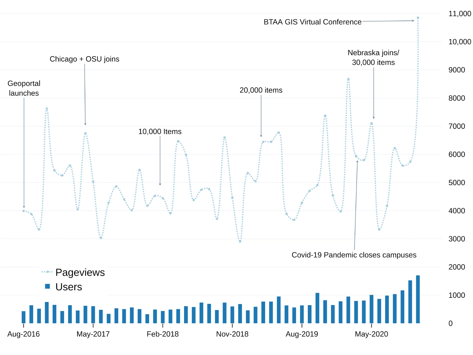
Since launching in 2016, the Geoportal has had a slowly rising base of users and pageviews, with usage patterns following the academic calendar. However, there has been a marked increase in 2020, possibly attributable to the growing collection size, the shift to online instruction, and the BTAA GIS Virtual Conference.
Appendix B: Key Project Milestones
Section titled “Appendix B: Key Project Milestones”Held kickoff meeting
First in-person project summit for Task Force with nine institutions
Hired metadata coordinator to develop metadata workflow
Indiana University joined
Launched BTAA Geoportal
Metadata, Collection Development, and Interface Committees formed
Completed first round of usability testing for geoportal
Chicago and Ohio State joined
Second in-person project summit resulting in a new governance model
Strategic Leadership Group (SLG) formed
Began contributing to the GeoBlacklight community
Communications Committee formed
Geoportal record count hit 10,000
Conducted second round of usability testing
ArcGIS Working Group and Analytics Working Group released project guidelines
Implemented thumbnails and advanced search
Upgraded to GeoBlacklight 2.0
Geoportal record count hit 20,000
Added an Open in ArcGIS button, tooltips, and a citation widget
Began holding regular communications blog sprints
SLG in-person meeting to discuss expansion and sustainability
Licensed Data pilot began
University of Nebraska joined
Held two metadata sprints
Geoportal record count hit 30,000
Released Impact Report
Released six tutorials
Organized and hosted the first BTAA GIS Conference
Developed a custom metadata editor
Appendix C: Geoportal Scholarship
Section titled “Appendix C: Geoportal Scholarship”Scholarship involving the BTAA Geospatial Data Project has resulted in an initial white paper, four published articles, and 16 presentations or posters at national or international conferences.
Scholarly Articles
Majewicz, K., Martindale, J., Kernik, M. (forthcoming 2021). Open Geospatial Data: A comparison of data cultures in local government. Paper presentation for IASSIST Annual Conference.
Battista, A., Majewicz, K., Balogh, S., & Hardy, D. (2018). Consortial Geospatial Data Collection: Toward Standards and Processes for Shared GeoBlacklight Metadata. Journal of Library Metadata, 1-18. DOI: https://doi.org/10.1080/19386389.2018.1443414
Blake, M. Majewicz, K. Mattke, R. & Weessies, K. W. (2017) A Spatial Collaboration: Building a Multi-Institution Geospatial Data Discovery Portal. Collaborative Librarianship: Vol. 9: Iss. 3, Article 7. Available at: https://digitalcommons.du.edu/collaborativelibrarianship/vol9/iss3/7
Blake, M., Majewicz, K. L., Tickner, A., Lam, J. (2017). Usability Analysis of the Big Ten Academic Alliance Geoportal: Findings and Recommendations for Improvement of the User Experience. Code4lib Journal, 38. http://journal.code4lib.org/articles/12932
Weessies K., Wilson, K. (2016) The long road to map discovery: two multi-institutional projects. Digital Approaches to Cartographic Heritage Riga 2016 Conference Proceedings. Edited by Evangelos Livieratos. Link
Bidney, M., Mattke, R. & Weessies, K. (2012). A Collaborative Vision for Spatial Scholarship Across the CIC. (white paper). Link
Selected Presentations:
2020
Majewicz, K. “A Tour of the BTAA Geoportal.” BTAA GIS Virtual Conference.
2019
Sadvari, J., Dotson, D. (The Ohio State University). “The Big Ten Academic Alliance Geoportal: Facilitating Geospatial Data Discovery and Access.” Ohio GIS Conference. Li, S., Kong, N. (Purdue University). “Evaluating Geoportal Performance with Web Analytics.” Association of American Geographers Annual Meeting.
2018
Reed, J. (Stanford University), Cramer, T. (Stanford University), Majewicz, K. (University of Minnesota). “Changing the Geospatial Data Landscape in Libraries.”, Coalition for Networked Information (CNI) Fall Meeting (forthcoming).
Majewicz, K. (University of Minnesota). “The Evolution of a Geospatial Metadata Workflow for the Big Ten Academic Alliance Geoportal.” Digital Library Federation (DLF) Annual Meeting.
Majewicz, K. (University of Minnesota), Durante, K. (Stanford University), Battista, A. (New York University), Hixson, T. (New York University). “Challenges in Harmonizing Geospatial Metadata.” IASSIST & CARTO Annual Conference.
Weesies, K. (Michigan State University), Kiser, T. (Michigan State University), Smeltekop, N. (Michigan State University), Tickner, A. (Michigan State University). “A Collaborative Geoportal for the Big Ten Region.”IASSIST & CARTO Annual Conference.
2017
Piekielek, N. (The Pennsylvania State University), Martindale, J. (University of Wisconsin), O’Neal, K. (University of Maryland). “BTAA Geoportal: An Update on Collections, Metadata and Interface Design.” North American Cartographic Information Society (NACIS).
Blake, M. (University of Michigan). “Big Ten Academic Alliance GeoBlacklight Interface and Usability Assessment.” Geo4LibCamp2017.
Majewicz, K. (University of Minnesota). “The Big Ten Academic Alliance Geospatial Data Project.” Geo4LibCamp2017.
Blake, M. (University of Michigan), Mattke. R. (University of Minnesota). “Building and evaluating the user experience of an Open Source geoportal: the Big Ten Academic Alliance Geoportal.” FOSS4G International Conference.
2016
Martindale, J. (University of Wisconsin), Majewicz, K. (University of Minnesota). “Transforming Geospatial Metadata for a Collaborative Geoportal.” Upper Midwest Geospatial Conference.
Kong, N. (Purdue University). “A Multiple Institutional Collaboration Project toward Geospatial Data Discovery.” Coalition for Networked Information (CNI) Spring Meeting
Weesies, K. (Michigan State University), Wilson, K. (Michigan State University). “The Long Road to Map Discovery: Two Multi-institutional Projects.” Digital Approaches to Cartographic Heritage / Map & Geoinformation Curators Group
Parker, B. (University of Maryland), Majewicz, K. (University of Minnesota). “Implementing Collaborative Metadata Workflows for the Geospatial Data Discovery Project.” Digital Library Federation (DLF) Annual Meeting.
2015
Mattke. R. (University of Minnesota). “CIC Geospatial Data Discovery Project.” North American Cartographic Information Society (NACIS)
Posters presented at National and International Conferences
2017
“Lessons in Collaboration: Building a Multi-Institution Geospatial Data Discovery Portal.” Association of College & Research Libraries (ACRL)
2016
“A Multi-institutional Geoportal to Enhance Geospatial Data Discoverability and Increase Accessibility.” American Association of Geographers Annual Conference
“The CIC Geospatial Data Discovery Project: A Multi-Institution Project to Create an Open-Source Discovery Portal for Geospatial Data Resources.” IASSIST Annual Conference and Charleston Conference
Appendix D: Project Staffing
Section titled “Appendix D: Project Staffing”Executive Committee
- Lisa German, Dean of Libraries & University Librarian - Minnesota
- Barbara Dewey, Dean of University Libraries & Scholarly Communications - Penn State
- Beth McNeil, Dean of Libraries - Purdue
- John Butler (ex-officio), AUL for Data & Technology - Minnesota
- Maurice York (ex-officio), Director of Library Initiatives - Big Ten Academic Alliance
Task Force Members (2021)
| Chicago | Cecilia Smith, GIS and Maps Librarian |
| Illinois | Wenjie Wang, GIS Specialist |
| Indiana | Jennifer Liss, Monographic Image Cataloging Librarian Theresa Quill, Social Sciences Librarian (GIS/Maps) |
| Iowa | Cathy Hodge, Monograph & Cartographic Resources Cataloging Librarian Jay Bowen, GIS Specialist |
| Maryland | Milan Budhathoki, Geospatial Librarian |
| Michigan | Caroline Kayko, Map and Geospatial Data Librarian Nicole Scholtz, Spatial and Numeric Data Librarian |
| Michigan State | Kathleen Weessies, Head, Map Library Amanda Tickner, GIS Specialist |
| Minnesota | Melinda Kernik, Spatial Data Analyst & Curator Laura McElfresh, Cartographic Metadata Librarian |
| Nebraska | Adonna Fleming, Professor Meg Mering, Coordinator of Cataloging and Metadata |
| Ohio State | Danny Dotson, Mathematical Sciences Librarian & Science Education Specialist Josh Sadvari, Geospatial Information Librarian |
| Penn State | Nathan Piekielek, Geospatial Services Librarian Jae Sung Kim, Open Source Geospatial Analyst |
| Purdue | Shirley Li, GIS Analyst Nicole Kong, GIS Specialist |
| Wisconsin | Jim Lacy, Associate State Cartographer Jaime Martindale, Map and Geospatial Data Librarian |
University of Minnesota Project Staff
- Ryan Mattke, Project Lead
- Karen Majewicz, Project Metadata Coordinator & Product Owner
- Melinda Kernik, Spatial Data Analyst & Curator
- Cody Hanson, Web Developer Lead
- Kirsten Clark, Project Sponsor
- Eric Larson, Lead Application Developer
- Paul Bramscher, Linux Systems Administrator and Software Administrator
- Michael Berkowski, Web Applications Developer