Geodata Collection Strategic Plan (2024-2026)
Summary:This document describes the BTAA-GIN Geodata Collection Strategic Plan for 2024-2026, including an overview of the expanded scope and the technology building blocks needed to meet this vision.
Prepared for: Big Ten Academic Alliance Library Directors
Revised February 2024
1. SUMMARY
Section titled “1. SUMMARY”This document describes the BTAA-GIN Geodata Collection Strategic Plan for 2024-2026, including an overview of the expanded scope and the technology building blocks needed to meet this vision.
Timeline Overview
Section titled “Timeline Overview”- Hire new staff
- Develop curation plan
- Run technology pilot
- Begin conducting active geodata curation
- Share documentation and perform outreach
- Assess & review
- Explore archiving & preservation strategies
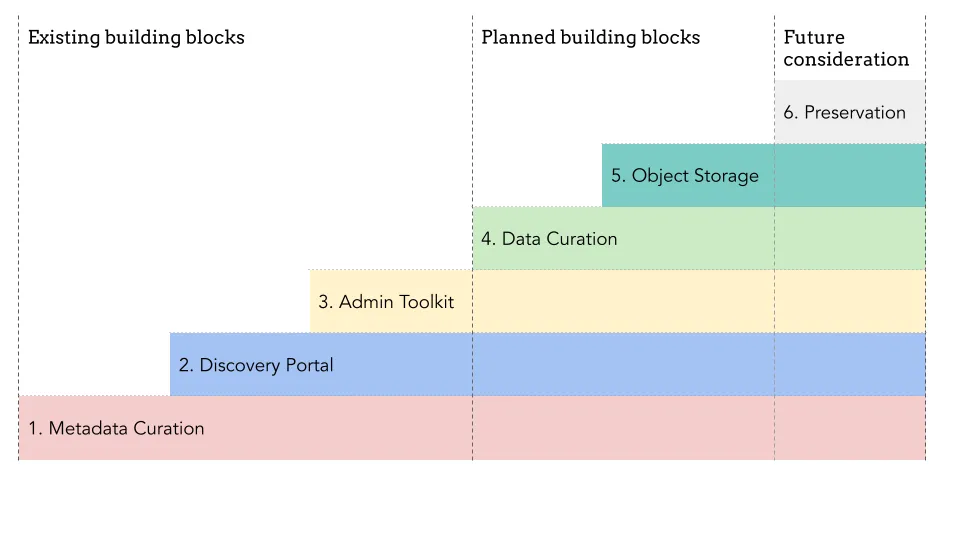
Incremental steps to building a BTAA-GIN Geodata Collection
Section titled “Incremental steps to building a BTAA-GIN Geodata Collection”- Metadata Curation: Collection and normalization of metadata.
- Discovery Portal: A geoportal for user-friendly discovery and access.
- Admin Toolkit: A workflow tool for ingesting, editing, and publishing assets.
- Data Curation: Evaluation, collection, and processing of geodata.
- Object Storage: A designated location for file storage and access.
- Preservation: Long term storage in a repository system.
2. JUSTIFICATION
Section titled “2. JUSTIFICATION”2.1 Background
Section titled “2.1 Background”The Big Ten Academic Alliance Geospatial Information Network launched the BTAA Geoportal in 2016 with a mission confined to curating and storing metadata, excluding the handling of actual data objects. In the intervening years, we have cataloged nearly 70,000 records for geospatial resources and improved their discoverability through metadata normalization and centralization.
2.2 The Need for Scope Expansion
Section titled “2.2 The Need for Scope Expansion”To continue to serve the BTAA research community effectively, we have concluded that we must also systematically capture geodata.
2.2.1 Addressing the User Experience
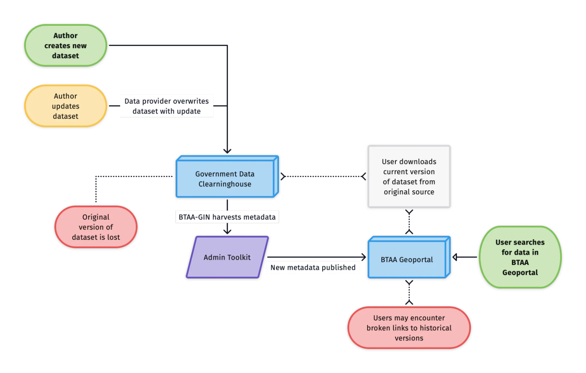
Section titled “2.2.1 Addressing the User Experience”Over time, we have encountered a recurring challenge: many providers update, migrate, or delete their datasets without preserving prior versions. Consequently, our Geoportal, which relies on external links, faces the vexing issue of “link rot.” This undermines both user experience and the community’s trust in our service. Broken links deter users from revisiting the site and saving records for future use. By storing dataset versions over time, we can offer a consistent and reliable service to our users.
2.1.2 Filling the Temporal Gap
Section titled “2.1.2 Filling the Temporal Gap”Academic libraries have well-established programs to collect and archive physical map collections. However, most libraries are collecting far fewer maps in recent years because government agencies now issue geospatial information as digital data instead of as maps. Unfortunately, many libraries have not yet updated their collection policies to include publicly available digital data. As a result, they are currently failing to capture the changing geospatial landscape for future researchers. Libraries must begin curating digital geodata to fill in the growing temporal gaps in their collections.
2.2 Anticipated Outcomes
Section titled “2.2 Anticipated Outcomes”2.2.1 A collection that will grow in value over time
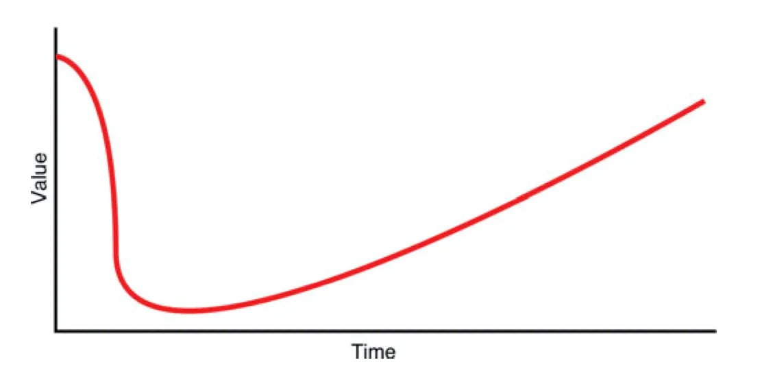
Section titled “2.2.1 A collection that will grow in value over time”When geospatial data is newly created, it holds high value due to its immediate relevance. As time passes, this data can seem less valuable as it becomes outdated or superseded by more current versions. However, its value can significantly increase later on as it gains historical significance. This can be illustrated by a U-shaped value curve, which shows an item’s high initial worth, a decrease in value as it ages, and a subsequent increase as it becomes historical. We will be making investments in our future value by collecting geodata now.
2.2.2 A significant contribution to the BIG Collection Initiative
Section titled “2.2.2 A significant contribution to the BIG Collection Initiative”The BIG Collection Initiative aims to create a cohesive network environment that provides universal content availability, enhances resource discovery, and ensures frictionless access. The initiative also prioritizes the long-term sustainability of both print and digital collections through coordinated preservation and digitization efforts. Our plan to curate geospatial data aligns with the B1G Collection Initiative, leveraging the collective strengths of BTAA libraries.
3. SCOPE EXPANSION
Section titled “3. SCOPE EXPANSION”3.1 Collection Policy
Section titled “3.1 Collection Policy”Our current collection policy covers metadata records for geodata and historical scanned maps. Our expanded policy will include a curated collection of public geodata, selectively chosen with the BTAA researchers in mind.
Geoportal Collections
| Collection | Hosting location | Status |
|---|---|---|
| Collection A: Data Registry Public and licensed geodata. | External data portals (state & local governments, research institutes, vendors, and libraries) | Active |
| Collection B: Library Repositories Scanned maps and curated geodata. | BTAA digital libraries | Active |
| Collection C: BTAA-GIN Geodata Foundational free and open public geodata layers from the recent past. | BTAA-GIN Amazon cloud storage | Planned |
3.2 Geodata Lifecycle
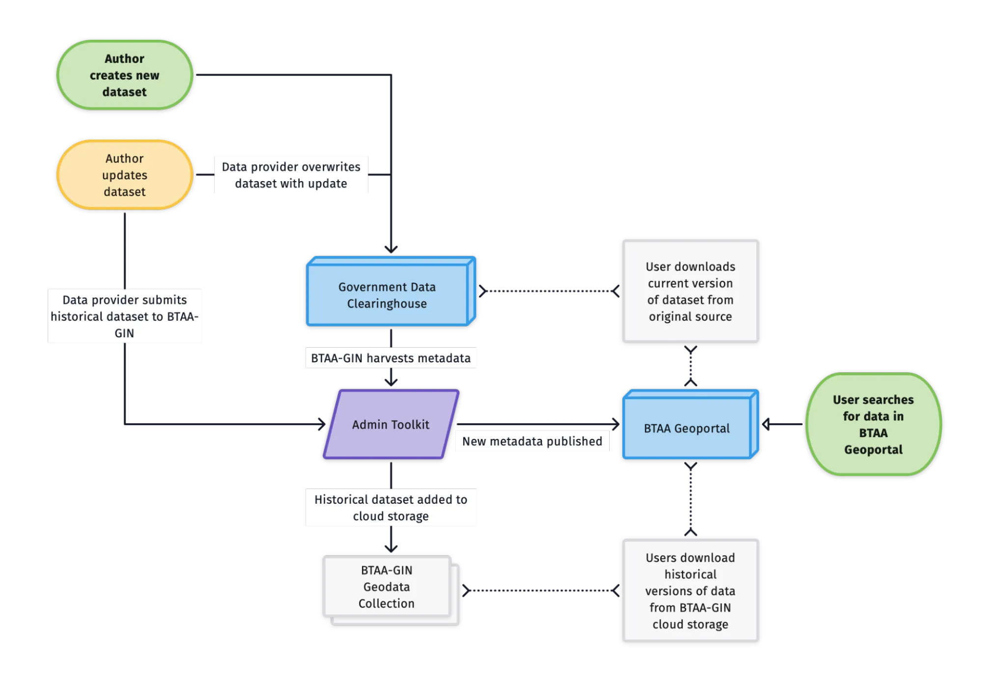
Section titled “3.2 Geodata Lifecycle”Under our current scope, we are only able to provide external links to the most recent versions of any dataset. When authors overwrite a public dataset, we must re-harvest the metadata and discard the previous version with its broken access links. Under our expanded scope, we will save versions of geodata before they are overwritten. Users will still be able to access current versions from the original data provider, but will also be able to download historical versions.
3.3 Staffing Plan
Section titled “3.3 Staffing Plan”3.3.1 Leadership Team
Section titled “3.3.1 Leadership Team”- Program Lead: Continues to lead strategic planning and coordination.
- Geospatial Product Manager: Remains in charge of technical management and adds data curation to portfolio. Other program current responsibilities shift to new hire (see below).
- Program and Outreach Coordinator (New): Manages community outreach and engagement, program coordination, and team management.
3.3.2 Development and Technical Implementation
Section titled “3.3.2 Development and Technical Implementation”- Lead Developer (Current, Part-time, Contracted): Role expands from one week to two weeks per month to focus on BTAA Geoportal and Admin Toolkit software applications.
- Cloud Solutions Consultant(s) (New, Temporary, Consultant): Collaborates with the Lead Developer and the University of Minnesota IT team to establish and optimize an Amazon Cloud-based storage infrastructure. This expertise may also be found in-house at one of the partner institutions.
3.3.3 Metadata and Data Curation
Section titled “3.3.3 Metadata and Data Curation”- Graduate Research Assistant (Current): Role may shift to focus more on processing data, under the direction of the Geospatial Product Coordinator.
- Program Team: Advises leadership team on identifying content, developing workflows, and maintaining communication with data providers.
4. FUTURE CONSIDERATIONS
Section titled “4. FUTURE CONSIDERATIONS”4.1 Emerging technologies
Section titled “4.1 Emerging technologies”Once we have transitioned to cloud object storage, we will be well-positioned to harness emerging technologies that improve user experience. Many of these innovations originate within BTAA institutions, making them prime candidates for collaborative implementation. For instance, the University of Minnesota’s groundbreaking Machines Reading Maps project offers a novel possibility: it can transform text from historical maps into searchable geocoded data. Similarly, we could adopt Northwestern University’s Serverless IIIF, an AWS serverless application that enables image views.
4.2 Preservation
Section titled “4.2 Preservation”While the long-term preservation of collected datasets is outside the framework of our immediate plans, it is an essential component that merits future evaluation. In the future, we will likely need to develop workflows that include duplicating datasets to more permanent storage locations, verification and validation to maintain data integrity, and migration processes to adapt to evolving technologies and formats.