March 2024 Program Status Update
Monthly Highlight
We had the honor of being invited by Yale University Libraries to present our expertise in GeoBlacklight, OpenGeoMetadata, and the BTAA Geoportal to their Associate University Librarians. Our overview included development requirements, metadata strategies, collaboration successes, and our recommended priorities.
Our slides are below:
Feedback afterwards indicated that we positively influenced Yale's decision to recommit to their geoportal development with an elevated focus on geospatial metadata.
Program Activities
Committees
- Determined six priority projects.
- Held a metadata Cleanup Sprint for March 22, 2024.
- Scheduled an April sprint to clean up Google Drive
- Update blog post schedule
- Discussing how to coordinate Program Team lightning talks
- Analyzed survey results of Team Member research priorities
- Drafted charters for two subgroups: Scalable Approaches and Service Models to coordinate the top research priorities
- Revised instructions for Priority Projects submissions to include all Team Members instead of just committee co-chairs.
- Made a schedule for upcoming discussion topics, including roadmaps and instituional priorities.
-
Workgroups
The Geodata Pilot Collection Workgroup continued researching potential pilot datasets from BTAA member states.
-
Program Management
- Issued a call for priority projects from all Team Members
- Continued including lightning talks during Team Meetings. Ryan presented on his participation in the National Geospatial Advisory Council.
BTAA Geoportal
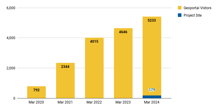
Analytics Statistics
March 2024 by the numbers
- Visitors: 5,233
- Visits: 5,906
- Downloads: 191
- Visits with download: 3.23%
- Outlinks: 1,181
- Visits with outlink: 20.00%
- Num. searches: 1,425
- Search keywords: 536
- Pageviews: 14,729
Unique visitors by month
Top 20 Internal Searches
| Site Search Keyword | March 2024 |
|---|---|
| afghanistan | 45 |
| sanborn | 43 |
| important farmlands | 33 |
| waukesha county | 27 |
| oregon plant conservation | 23 |
| congo | 22 |
| health | 19 |
| Address point | 17 |
| oregon ecology | 16 |
| vegetation | 13 |
| syria | 13 |
| new york city | 13 |
| baltimore | 13 |
| Damascus | 12 |
| wildlife and Ohio | 11 |
| israel | 11 |
| DS1104-2138DF006 | 11 |
| crime stats in michigan | 10 |
| Turkey | 10 |
| Slovakia | 10 |
More stats
See full statistics on our Analytics Dashboard
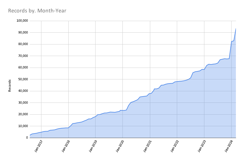
Collections
Total records as of April 1, 2024: 93,648
March Harvesting Activities
Development
We did not pursue application development during March 2024.
Next Steps
The next steps on our Program Roadmap 2023-2024 include the following tasks:
- Governance: Develop a priority projects matrix
- Public documentation: Teach the Team Members how to write in Markdown and contribute to our new website.
Upcoming highlight: In April, our graduate student research assistant will be delivering a public presentation about OpenIndexMaps featuring historical maps in the BTAA Geoportal.