February 2024 Program Status Update
Monthly Highlight: Northwestern University Joins the BTAA-GIN

We are pleased to announce that Northwestern University has become a member of the Big Ten Academic Alliance Geospatial Information Network (BTAA-GIN). This addition to our network signifies a notable development in our efforts to enhance the collective resources and expertise available to our members.
- New Team Members from Northwestern University: We welcome Méch Frazier, GIS Specialist, and Kelsey James Rydland, Head of Digital Scholarship & Research Data Management, from Northwestern University.
- Network Expansion: With the addition of Northwestern University, the BTAA-GIN now comprises 15 participating institutions. This expansion underscores the network's commitment to supporting geospatial research and education across the entire BTAA.
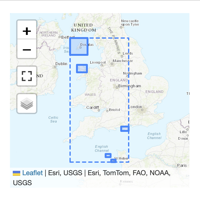
- Updated Participant Map: Our participant map has been updated by team member Jay Bowen to include Northwestern University.
- Contribution of Scanned Maps: Northwestern University has contributed 250 scanned maps from their Digital Collections to the BTAA Geoportal. These contributions are from their "16th-Early 20th Century Maps of Africa" and "Maps and Atlases" collections. These maps are now accessible through the BTAA-GIN portal here.
Program Activities
Committees
- Worked on harmful language statement and identified the need to update our policies for accessibility, privacy, and usage.
- Reviewed work from sunsetted Interface Committee.
- Decided to close ongoing anonymous geoportal survey, as sufficient feedback has been gathered.
- Scheduled a metadata Cleanup Sprint for March 22, 2024.
- Collected a list of helpful BTAA-GIN templates and documents
- Planning a sprint to clean up Google Drive
- Completed a member survey to identify research priorities as BTAA institutions
- Began analyzing survey results
- Devised new structure for Team Meetings to emphasize knowledge sharing and discussions.
- Issued a call for Priority Projects from each committee.
-
Workgroups
The Geodata Pilot Collection Workgroup began researching potential pilot datasets from BTAA member states.
-
Program Management
- We held the first iteration of our revamped monthly Team Meetings that included a lightning presentation, round robin sharing, and discussions.
- We consulted with University of Minnesota library leadership about creating a new position that would be responsible for program & outreach coordination.
BTAA Geoportal
Analytics Statistics
February 2024 by the numbers
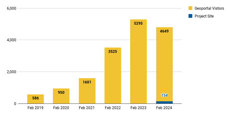
- Visitors: 4,649
- Visits: 5,258
- Downloads: 361
- Visits with download: 6.3%
- Outlinks: 1,190
- Visits with outlink: 22.63%
- Num. searches: 2,415
- Search keywords: 691
- Pageviews: 14,115
Unique visitors by month
More stats
See full statistics on our Analytics Dashboard
Collections
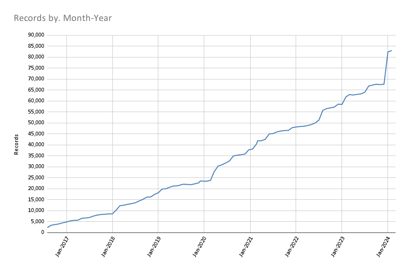
Total records as of March 1, 2024: 83,002
February Harvesting Activities
Development
- We started a Technology Roadmap for the calendar year 2024 to prioritize our needs for a geodata collection pilot.
- We added a facet to filter maps that have been georeferenced.
- We updated the display of complex geometries in the location inset. Now, the rectangular bounding box appears as a dotted line, with the item exent as a solid polygon.
More development details
Read the full February Development Tasks report for more details.
Next Steps
The next steps on our Program Roadmap 2023-2024 include the following tasks:
- Governance: Develop a priority projects matrix
- Public documentation: Teach the Team Members how to write in Markdown and contribute to our new website.