TECHnology
- Collections Policy working group met and is asking for more member participation
- Completed mini-sprint evaluating IIIF resources

More than two years ago, BTAA-GIN began developing the workflows and infrastructure needed to archive geospatial data itself. A series of pilots allowed the program to test approaches to acquiring, processing, documenting, and preserving datasets.
In fall 2025, that groundwork led to the launch of Urban Base Layers, an initiative to regularly collect and collect snapshots of foundational municipal datasets such as zoning, roads, address points, buildings, and administrative boundaries. The project began with four cities and has since expanded to 13. Local GIN members help initiate the work by connecting with municipal GIS staff, deepening connections between member universities and local data providers.
BTAA-GIN now captures municipal datasets before routine updates overwrite previous versions. With annual collecting planned, each successive snapshot will add another point to the historical record, building a collection researchers can use to study how cities change over time. The most recent additions were initiated by Matthew Parsons at the University of Washington, Theresa Quill at Indiana University, Mech Frazier at Northwestern University, and Nicole Scholtz at University of Michigan.
Urban Base Layers puts the warning raised in BTAA-GIN’s award-winning Ephemeral Geodata: An Impending Digital Dark Age research into practice, turning an identified preservation problem into a sustainable response.
Read more: Explore the Urban Base Layers Collection »
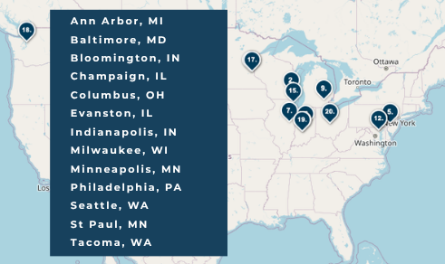
BTAA-GIN Urban Base Layers Cities as of Oct 2026
TECHnology
Community Engagement
Knowledge
Coordination
Workgroups
Add one or more workgroup updates.
September total monthly visits year over year
Total records as of September 2026: 147,851
View current harvest operations dashboard.
Add web development updates.