BTAA-GIN Work Featured at Fall Conferences
In fall of 2026, BTAA-GIN members presented the network’s work at regional and national conferences serving data librarians, map librarians, and GIS professionals. The sessions shared what we are learning, trying, and doing with the wider geolibrarianship community.
- Introducing BTAA-GIN: Jaime Martindale (University of Wisconsin-Madison) presented an overview of the consortium’s collaborative programs, collections, and services at the B1G Cartography Lab Workshop.
- BTAA-GIN Tools and Preservation Initiatives: Amanda Tickner (Michigan State University) and Nicole Scholtz (University of Michigan) presented the history and evolution of BTAA-GIN, including the Geoportal, the Data Citation Generator, and future work to preserve ephemeral geospatial datasets at the CMPASS Educational Conference.
- Data Governance and Long-Term Preservation: Jaime Martindale and Karen Majewicz (BTAA-GIN) joined a GIS-Pro panel of map librarians and GIS professionals on organizing, documenting, and preserving spatial data over time.
- Geospatial Data Archiving and Preservation: Karen Majewicz (BTAA-GIN) discussed community efforts, open-source tools, and long-term strategies for preserving public geospatial resources at FOSS4G.
- BTAA-GIN Geospatial API: Eric Larson (BTAA-GIN) described the architecture and future applications of BTAA-GIN’s next-generation geospatial platform at FOSS4G.
- Data Citation Generator: Innocensia Achieng Owuor (Purdue University) demonstrated the BTAA-GIN Data Citation Generator and discussed how the tool helps address challenges in citing geospatial data accurately and consistently at the Midwest Data Librarian Symposium.
- BTAA BIG Map Collection: Theresa Quill (Indiana University), Heather Ross (Penn State University), and Kathleen Weessies (Michigan State University) shared an update on the initiative and ongoing collaborative efforts to improve access to cartographic resources at the Western Association of Map Libraries (WAML) Conference.
Program Activities
Committees
TECHnology
- Collaborated with CEC on Geoportal demo
- Set charge for the Collections sub-group
Community Engagement
- Live Geoportal Demo Webinar went well with 76 attendees and 206 registrants
- Planning is kicking off for the Big Ten GIS Conference
Knowledge
- Continued conversations on the potential of research/interest groups around research survey results
- Shared out what people are doing at their own libraries with AI
Coordination
- Committee gave feedback on first draft of 2026 Impact Report
- Held discussion on Geoportal Metadata Planning facilitated by Karen Majewicz, Metadata Coordinator
Workgroups
Workgroups
Data Citation
- Multiple conference presentations of the Data Citation Generator: CMPASS Educational Conference and Midwest Data Librarian Symposium.
BTAA Geoportal
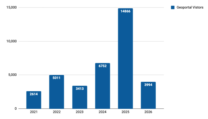
This month by the numbers
Top Google searches leading to the Geoportal
- btaa geoportal
- sanborn maps nyc
- abandoned buildings near me
- central ohio school district map
- warren county ohio gis
- sanborn maps
- columbus school district map
- columbus ohio school district map
- big geoportal
- grand trunk road map
Top internal search keywords
- towns alaska
- sanborn
- russia
- street
- climate
- Pennsylvania
- michigan
- sri lanka
- forest
- cta bus
Collections
Total records as of Nov 5, 2026: 149,336
Harvesting Activities
View current harvest operations dashboard.
Web Development
Project Board