TECHnology
- Meeting canceled due to focus on Geoportal launch.

BTAA-GIN participated in Geo4LibCamp 2026 at a significant moment for the program. The new BTAA Geoportal was nearing launch, and the conference's discussions on how to preserve public geodata, how to build infrastructure that lasts, and how to support metadata creation closely tracked the program's own recent work.
Karen Majewicz, Associate Director of Technology and Data Curation, presented the program's Urban Base Layers project, which preserves city-level geospatial data published through open data portals and ArcGIS Hubs. The discussion that followed surfaced shared challenges with preservation of public geodata across institutions: uncertain licensing, limited staff time, and inconsistent relationships with government data providers.
Majewicz and Eric Larson, the software developer for the BTAA Geoportal, also led a workshop on the new BTAA Geospatial API, which extends open-source standards including GeoBlacklight and OpenGeoMetadata with new search features and documentation built for reuse at other institutions.
Both sessions reflect a question the broader field is still working out: how to keep public geospatial data usable over time, in ways other institutions can build on rather than start over.
TECHnology
Community Engagement
Knowledge
Coordination
Workgroups
Add updates for this workgroup.
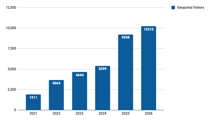
June monthly users year-over-year
Total records as of July 2026: 130,691
View current harvest operations dashboard.