We are thrilled to welcome the University of Oregon and the University of Washington to the Big Ten Academic Alliance Geospatial Information Network (BTAA-GIN). Their addition marks an exciting step forward in our mission to enhance the resources and expertise available to our members and the broader geospatial research community.
We welcome our new team members:
University of Oregon
Gabriele Hayden, Head of Data Services
Kathy Stroud, Cartographic and Government Information Librarian
University of Washington
Matt Parsons, Geospatial Data & Maps Librarian
Allison Anderson, GIS Infrastructure and Support Specialist
This growth strengthens our collective ability to support geospatial research and education, laying the groundwork for new collaborations that will benefit all BTAA-GIN members.
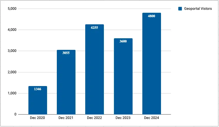
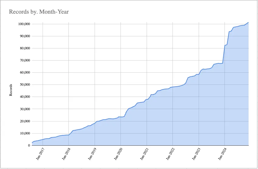
Collection Expansion: We look forward to collaborating with each institution to identify data and digital map collections that will enrich the Geoportal, which boasts over 100,000 resources.
Network Expansion: With these new members, the BTAA-GIN now includes 17 institutions, spanning coast to coast. This expansion highlights our commitment to supporting geospatial research and education across the BTAA. As one of the largest collaborations of its kind in the field of GIS, our network continues to grow in size and value, amplifying its positive impact on geospatial data and research.
A History of Collaboration: For over 9 years, the BTAA-GIN has exemplified academic collaboration, creating opportunities and driving innovation in geospatial services and tools across its member universities. The integration of these two renowned universities further boosts our shared influence and available resources.
Reviewed new metadata fields and potential data dictionary
Reviewed workgroup activities
Ended with a group metadata cleanup session
Community Engagement
No meeting in December.
Knowledge
New Program & Outreach hire, Colleen Wilson, shared what she’s been working on and outlined upcoming plans. She will join as an ongoing committee member.
Next meeting will be Tuesday, January 28, 2025.
Coordination
Set guidelines for cross-BTAA meetings to take place between: 11am and 3pm (central)
Planned agenda for next program team meeting to focus on new member introductions
MARC to GeoBTAA Metadata Crosswalk: Mapped GeoBTAA fields to MARC fields but needs to reverse the process to ensure all MARC fields are accounted for.
Next Steps: Share the crosswalk in an accessible format and create a new sheet for maps metadata, including new fields for series names, spatial resolution, and tags.
Drafted a new survey to explore tiered service models and compensation practices among BTAA-GIN members and beyond, focusing on service definitions, tier structures, and staffing. The plan is to share a revised draft with the larger program team in January.
Like many other rich-content websites, the Geoportal has lately been overwhelmed by AI bots, causing major slowdowns and outages. We have blocked traffic from certain regions, but the problem persists globally. A stronger security system, like a web application firewall, is a top priority for 2025.
Improved Data Organization
Our introduction of stored assets complicated our established workflow for adding links, such as downloads, supplemental metadata, and external website addresses. To improve our metadata management, we overhauled our GBL Admin database to migrate these links into a separate table. In addition to simplifying our descriptive metadata workflow, this separation allows us to use structured fields to describe the links.
Work In-progress
Implementing data dictionaries.
Preparing for necessary server and framework updates in early 2025.