Skip to content

February 2025 Program Update

Building a Sustainable Geodata Repository: BTAA-GIN Pilot Phase Complete

Section titled “Building a Sustainable Geodata Repository: BTAA-GIN Pilot Phase Complete”

The BTAA-GIN Geodata Pilot Workgroup has successfully completed its current phase, establishing the technical and metadata infrastructure for a scalable geospatial repository. Over the past year (Q1 2024-Q1 2025), the workgroup focused on building a framework for data curation, refining metadata standards, and improving workflow automation.

Read the full report here

  • curated a pilot collection of 35 datasets on our development site to test our processes for gathering, describing, and sharing geospatial information
  • added new metadata fields and entry guidelines to provide technical and administrative documentation for datasets
  • created new methods for programmatically generating metadata and derivative files from collected datasets
  • introduced new ways for users to evaluate datasets with visual previews and data dictionaries

The next phase, Foundation (2025-26), will feature our activites to:

  • partner with data providers to develop a process for exchanging resources
  • continue to enhance the BTAA Geoportal and backend management tools
  • curate real-world data submissions to build our first official collections
  • release a formal plan that documents our goals, workflows, and guidelines

TECHnology

  • Reviewed new item page design.
  • Previewed the draft Strategic Technology Plan 2025-2026.
  • Reviewed candidates for potential data preservation/rescue and discussed the benefits of establishing a workgroup to update the collection development policy.
Community Engagement

  • Shared a list of potential candidates for the geospatial data archiving pilot and government data rescue with the Tech Committee.
  • Completed two sprints to storyboard videos introducing GIN and providing Geoportal walkthroughs.

Knowledge

  • Proposed discussing and brainstorming at-risk state datasets for the geospatial data archiving pilot at the next Program Team meeting as well as initiating a workgroup to align this with our mission and workflows.
  • Still seeking members for the Geospatial Data Citation group.
  • Transactions in GIS CFP on spatial data sharing presents a potential publication opportunity tied to data citation, platform promotion, and data privacy, with a discussion planned for the 3/13 Program Team meeting.

Coordination

  • Reviewed drafts of two new documents
  • Strategic Technology Plan 2025-2026
  • Geodata Collection Groundwork Phase Report
  • Onboarding of new members is ongoing. USC will participate in our monthly meetings until a final membership decision is made in July 2025.
  • Our annual conference has a new name: Big Ten GIS Conference 202- Promotion for the Call for Proposals & Maps begins this month.

Workgroup has been sunset and the final report has been published.

  • Published revised metadata for maps; still need to add new metadata fields to Geoportal item page.
  • May sunset the workgroup after next TECH Committee meeting.
  • Draft survey in progress. Expected to circulate in the next month.

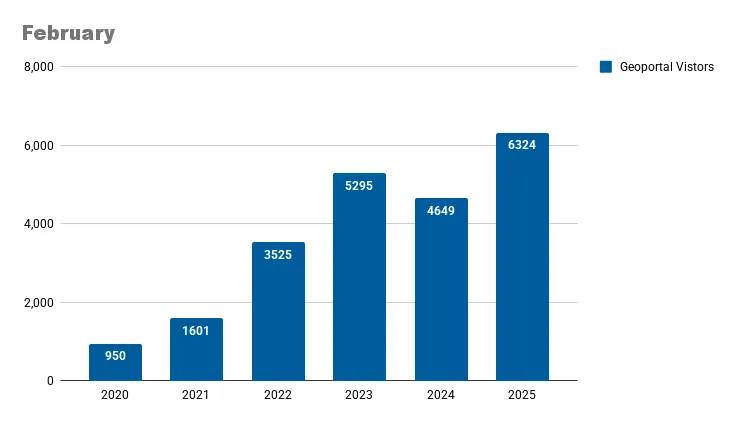
Unique visitors by month Geoportal visitors in May 2025.

Top Google searches leading to the Geoportal

Section titled “Top Google searches leading to the Geoportal”
  • btaa geoportal
  • ohio school district map
  • south bend city limits
  • franklin county school district map
  • nj wetlands map
  • 1937 aerial photographs wisconsin
  • st. louis county gis mn
  • maryland mile marker map
  • how many states were there in 1800
  • evansville city limits
  • Redlining
  • Bear
  • Uses
  • Hennepin county
  • Sanborn
  • Detroit
  • Oregon forest
  • Contaminated water
  • Erosion
  • wildlife

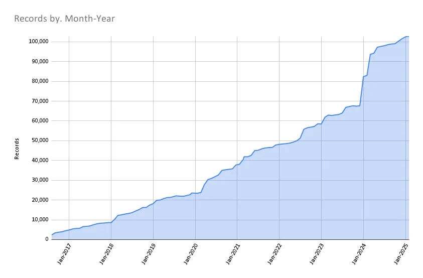
Total records as of March 1, 2025: 102,823

Records Mar1 2025

BTAA Geoportal Records from 2016 to March 1, 2025

TaskRecords addedRecords retired
Reharvest Minnesota Geospatial Commons February 202522
Minnesota Geospatial Commons January 202501
New Minnesota Digital Library: UMN Duluth410
New Minnesota Digital Library: Stillwater220
Washington State Open Data website record10
Oregon GeoHub website record10
Harvest Oregon GeoHub1780
2025-01-21 Scan ArcGIS Hubs295199
2025-02-04 Scan ArcGIS Hubs134319
2025-02-11 Scan ArcGIS Hubs162336
2025-02-18 Scan ArcGIS Hubs206327
2025-02-25 Scan ArcGIS Hubs219403
Reharvest Wisconsin OpenGeometadata 2025-02300
  • Geoportal Updates: Launched a new item view page redesign, added a Big Ten GIS Conference banner, updated Allmaps facets and sidebar tools, and upgraded to Rails 7.-
  • Rails 7.2 Upgrade: Provides about 1.5 years before Blacklight v7 and GeoBlacklight v4 reach the end of Rails’ security support window.
  • Conferences & Collaboration: Wrapped up the month at Stanford’s David Rumsey Map Center with discussions on IIIF, IIIF+Maps, and Allmaps, and gave a FastAPI+React demo to GeoBlacklight developers.