TECHnology
- Working on website policies and updating the Geoportal footer links
- Created a local gazeteer for counties, states, and nations
A new article titled “Ephemeral Geodata: An Impending Digital Dark Age,” co-authored by four BTAA-GIN Team Members, was recently published in the Journal of Map & Geography Libraries. The authors explore a long-standing challenge for our program, framing the lack of public geodata archives as a “looming digital dark age.” This analysis is based on our experiences managing the BTAA Geoportal and GeoData@Wisconsin, as well as our roles as map librarians. This article not only highlights a widespread issue but also provides a compelling rationale for our new initiative, the BTAA-GIN Geodata Collection, which aims to address gaps in the availability and accessibility of geospatial resources.
TECHnology
Community Engagement
Knowledge
Did not meet in September
Coordination
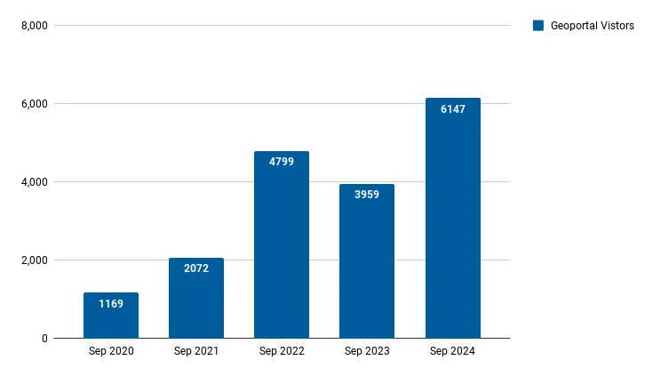
Total records as of October 1, 2024: 98,897
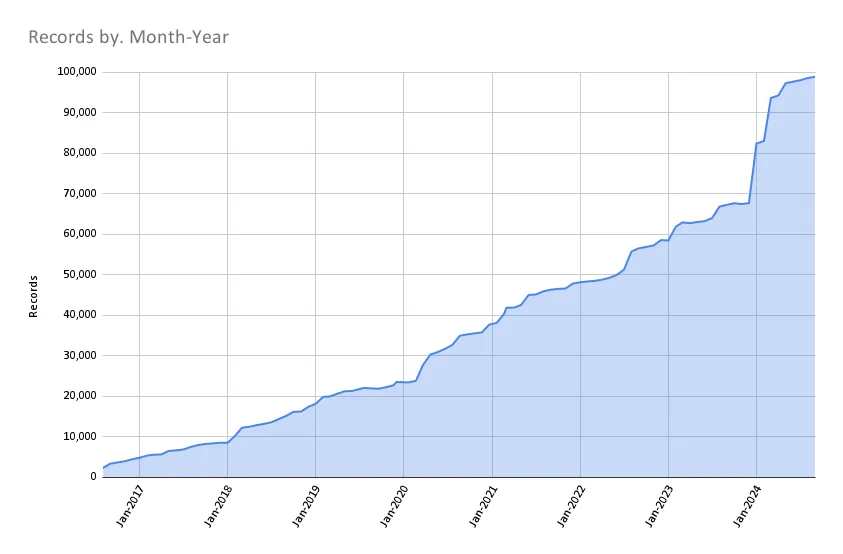
| Task | Records added | Records retired |
|---|---|---|
| MN Geospatial Commons 05a-01 September 2024 | 5 | 0 |
| 2024-09-03 Scan ArcGIS Hubs | 378 | 133 |
| 2024-09-10 Scan ArcGIS Hubs | 119 | 192 |
| 2024-09-17 Scan ArcGIS Hubs | 114 | 0 |
| 2024-09-24 Scan ArcGIS Hubs | 101 | 24 |
| Auglaize County, Ohio GIS Open Data Downloads | 21 | 0 |
| New Wisconsin records | 100 | 0 |
Projects and tasks that are up next include:
Refer to our Priority Projects board for more details.