TECHnology
Section titled “TECHnology”- Reviewed and submitted six priority projects
- Reviewed results of metadata sprint
We recently added five OpenIndexMaps for 19th century atlases of the Mississippi River. Now, researchers can use an index map within the Geoportal to find and select atlas pages based upon location.
These OpenIndexMaps were created by our 2023-24 graduate research assistant, Owen Connolly. Owen delivered a presentation in April about this work to the Program Team, describing the creation process and demonstrating how the OpenIndexMap GeoJSON format can be ingested into ArcGIS StoryMaps to create interactive narratives.
Owen is the 7th graduate research assistant our program has supported. Several of these students have extended their position to fulfill requirements for the University of Minnesota’s Master of GIS (MGIS) degree program, including internships, research credits, and delivering public presentations.
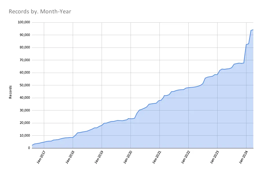
Total records as of May 1, 2024: 94,242
| Task | Records added | Records retired |
|---|---|---|
| Harvest 08a-01 Q2 2024 | 1 | 0 |
| Add Illinois DOT | 1 | 0 |
| Reharvest 02a-01 Q1 2024 | 1 | 0 |
| Add Iowa parcels | 55 | 0 |
| ArcGIS Hub Harvest 2024-04-03 | 147 | 0 |
| ArcGIS Hub Harvest 2024-04-10 | 139 | 248 |
| 2024-04 Wisc updates | 401 | 0 |
| Add OpenIndexMaps | 5 | 0 |
| ArcGIS Hub Harvest 2024-04-24 | 235 | 358 |
We are nearing completion of our next steps on our Revamping the BTAA GIN: a Program Roadmap (2023-2024), which includes the following milestones: