Skip to content

Geodata collection roadmap

Summary: Tracking page for the BTAA-GIN Geodata Collection

This page tracks our progress. It is updated frequently as our work evolves.

Date last updated: October 23, 2025

We are currently in Phase 3: Foundation.

Geodata Collection

The BTAA-GIN has launched an initiative to collect, store, and distribute open geodata.

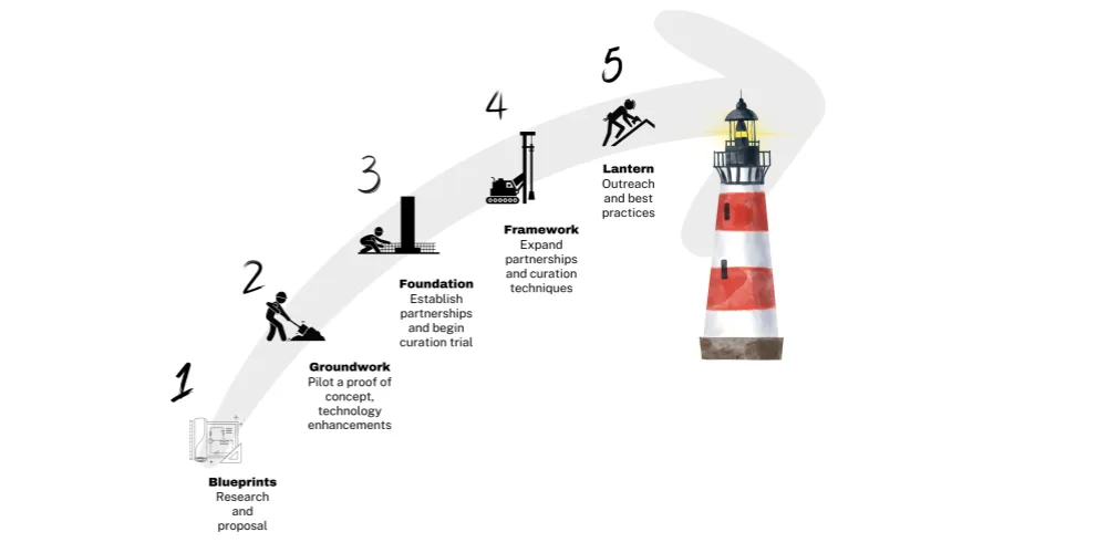
The Blueprints Phase represents the culmination of a lengthy period of time (beginning in 2015) that we put into researching geodata archiving. The research resulted in multiple scholarly articles1, reports2, and nascent proposals3. Finally, in 2023, we submitted the BTAA-GIN Geodata Collection Strategic Plan, which was approved by the BTAA-GIN Executive Committee.


During the Groundwork Phase, we focus on exploring the potential for a Geodata Collection and conducting a pilot. This phase involves experimenting with a variety of datasets to test workflows, metadata, tools, and data curation strategies. The goal is to establish a Proof of Concept.

Set up storage, basic ingest, and a pilot workgroup.

  • Establish the Geodata Collection Pilot Working Group.
  • Compile an environmental scan of existing geodata archiving practices across the BTAA region.
  • Assess current team capabilities and identify gaps in skill or resources.
  • Draft job description for a Program and Outreach Coordinator.
  • Advertise the position.
  • Establish Amazon cloud storage (S3) accounts for data storage.
  • Develop techniques within GBL Admin for basic ingest of datasets.
  • Create a few sample datasets in a GitHub repository to serve as test objects.
  • Add the test datasets to Amazon S3.
  • Ingest sample data to GBL Admin.
  • Create and publish a Geodata Collection Implementation Plan that expands on the Strategic Plan.

Build the pilot collection, explore technology enhancements, and document the results.

  • Determine staging environment for sharing datasets.
  • Select a broader range of pilot datasets.
  • Test new GBL Admin features for data management.
  • Determine minimum metadata requirements.
  • Augment the GeoBTAA Metadata Application Profile as needed.
  • Determine Download package contents.
  • Download pilot datasets to staging area
  • Add pilot datasets to GBL Admin.
  • Set up a staging area (Box).
  • Separate references into Distribution table
  • Incorporate data dictionaries
  • Continue process for interviewing for new position
  • Finalize the hiring process and onboard new hire
  • Document the setup and configuration processes for asset management tools.
  • Produce a final report of the working group activities.
  • Produce a report documenting the pilot collection and technology enhancements.

During the Foundation Phase, we begin collaborating with select data providers. This phase emphasizes building relationships, refining curation techniques, and establishing the first official collections. This work informs the development of key protocols and processes that will serve as the foundation for the project moving forward.

3a. Partnerships & Technology (Q1-Q3 2025)

Section titled “3a. Partnerships & Technology (Q1-Q3 2025)”

Communicate our newly developed capabilities and seek out data provider partnerships for our first collections.

  • Sunset the pilot workgroup.
  • Convene a Data Curation Workgroup. (name TBD)
  • Redesign the item view page Incorporate tabs for metadata, data dictionaries, and download options into item page view.
  • Transition the updated Geoportal interface from the development branch to the live environment.
  • Propose a dataset exchange workflow between data providers and the BTAA-GIN.
  • Present results of Groundwork Phase to key stakeholders
  • Establish partnership with one data provider
  • Outline a Curation Plan that includes initial scope, workflows, and criteria. See the Urban Base Layers Curation Plan.

3b. Collection & Curation Plan (Q3 2025-Q1 2026)

Section titled “3b. Collection & Curation Plan (Q3 2025-Q1 2026)”

Work iteratively with our data providers to collect, document, and publish prior versions of their datasets.

  • Ingest datasets submitted by partners
  • Review the initial collection
  • Establish partnership with a second data provider
  • Work with partners to refine the metadata and datasets for their original content as displayed in the Geoportal
  • Implement batch ingest functionality in GBL Admin.
  • Create a Download Package
  • Publish a Curation Plan, Version 1 to document scope, metadata, and workflows.

In the Framework Phase, we will build up our collections with more data providers. This will require broader communication and more outreach. We will also be relying on more streamlined workflows by this phase. This phase will include gathering feedback from stakeholders, refining workflows, and assessing the long-term sustainability of the collection. Additionally, we will increase our outreach efforts, promoting the collection to a broader audience and building partnerships to ensure its growth and visibility in the geospatial and library communities.

  • Expand partnerships and collections.
  • Incorporate additional and multipart formats
  • Establish regular cycles for collection.
  • Implement additional batch processing techniques
  • Publish Curation Plan Version 2.

  • Gather feedback from a wide variety of stakeholders.
  • Assess the project’s impact on users and stakeholders.
  • Evaluate how well the first version of the curation plan functions.
  1. See Dyke, K. R., Mattke, R., Kne, L., & Rounds, S. (2016). Placing Data in the Land of 10,000 Lakes: Navigating the History and Future of Geospatial Data Production, Stewardship, and Archiving in Minnesota. Journal of Map & Geography Libraries, 12(1), 52–72. https://doi.org/10.1080/15420353.2015.1073655; Majewicz, K., J. Martindale, M. Kernik, and R. Mattke. 2024. Ephemeral geodata: An impending digital dark age. Journal of Map & Geography Libraries 20 (2):88–113. https://doi:10.1080/15420353.2024.2398542.

  2. See the reports of the Minnesota Geospatial Advisory Committee’s Archiving Workgroup

  3. See the partially realized proposal from 2019, A Spatial Data Infrastructure (SDI) for the BTAA