Content Organization Model
Summary:How we organize records in the BTAA Geoportal
GeoBlacklight organizes records with a network model rather than with a hierarchical model. It is a flat system whereby every database entry is a “Layer” and uses the same metadata fields. Unlike many digital library applications, it does not have different types of records for entities such as “communities,” “collections,” or “groups.” As a result, it does not present a breadcrumb navigation structure, and all records appear in the same catalog directory with the URL of https:geo.btaa.org/catalog/ID.
Instead of a hierarchy, GeoBlacklight relates records via metadata fields. These fields include Member Of, Is Part Of, Is Version Of, Source, and a general Relation. This flexibility allows records to be presented in several different ways. For example, records can have multiple parent/child/grandchild/sibling relationships. In addition, they can be nested (i.e., a collection can belong to another collection). They can also connect data layers about similar topics or represent different years in a series.
The following diagram illustrates how the BTAA Geoportal organizes records. The connecting arrow lines indicate the name of the relationship. The labels reflect each record’s Resource Class (Collections, Websites, Datasets, Maps, Web services).
Resource Classes
Section titled “Resource Classes”Collections
Section titled “Collections”The BTAA Geoportal interprets the Resource Class, Collections, as top-level, custom groupings. These reflect our curation activities and priorities.
Other records are linked to Collections using the Member Of field. The ID of the parent record is added to the child record only. View all of the current Collections in the geoportal at this link:
https://geo.btaa.org/?f%5Bgbl_resourceClass_sm%5D%5B%5D=Collections
Websites
Section titled “Websites”The BTAA Geoportal uses the Resource Class, Websites, to create parent records for data portals, digital libraries, dashboards, and interactive maps. These often start off as standalone records. Once the items in a website have been indexed, they will have child records.
Individual Datasets, Maps, or Web services are linked to the Website they came from using the Is Part Of field. The ID of the parent record is added to the child record only.
View all of the current Websites in the geoportal at this link: https://geo.btaa.org/?f%5Bgbl_resourceClass_sm%5D%5B%5D=Websites
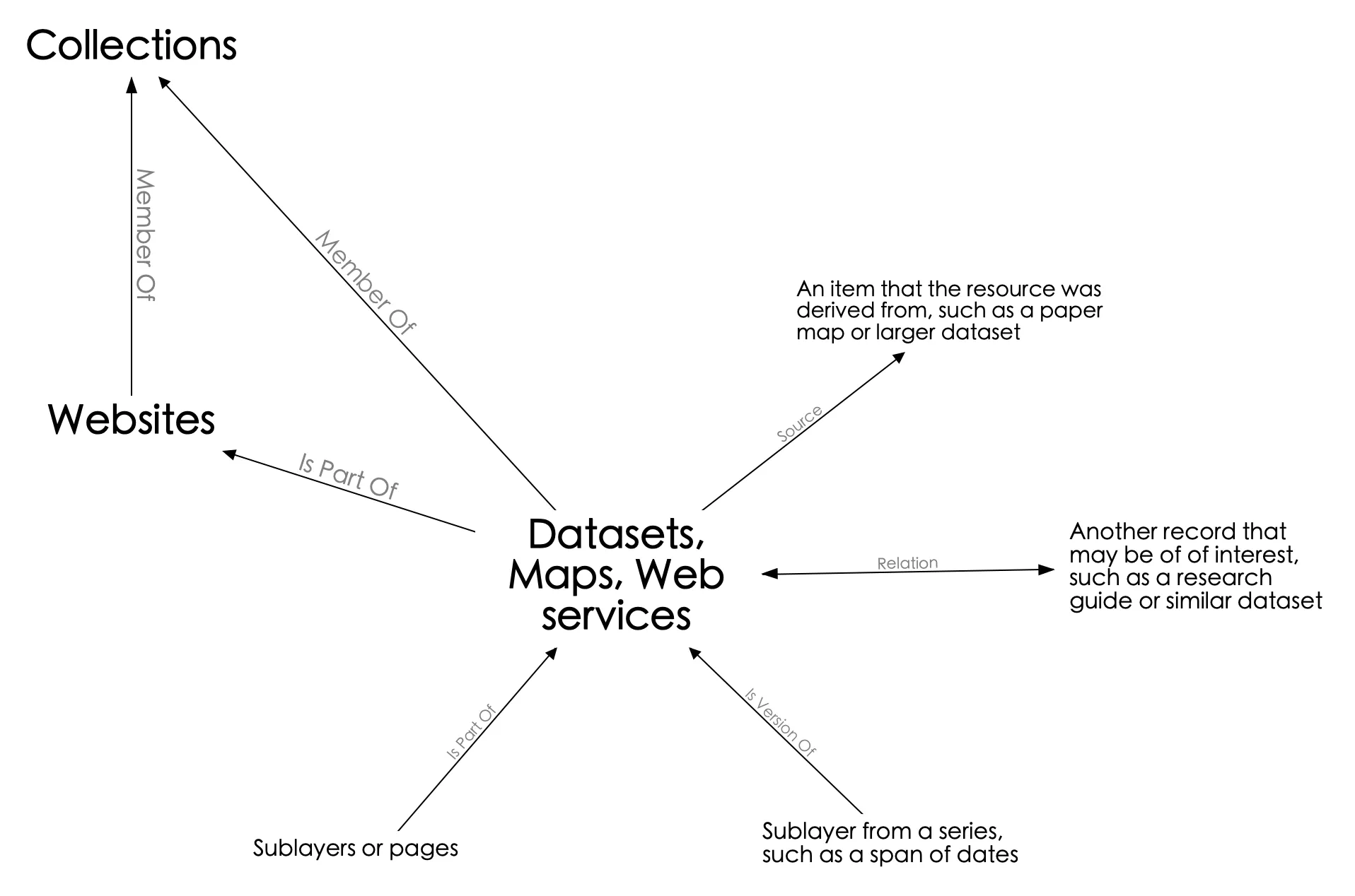
Datasets, Maps, and Web services
Section titled “Datasets, Maps, and Web services”The items in this Resource Class represent individual data layers, scanned map files, and/or geospatial web services. (Some items may have multiple Resource Classes attached to the same record.)
This item class is likely to have the most relationships specified in the metadata. A typical Datasets record might have the following:
Member Ofa Collections recordIs Part Ofa Websites record- If the data was digitized from a paper map in the geoportal, it can be linked to the Maps record via the
Sourcerelation - a general
Relationto a research guide or similar dataset
Multipart Items
Section titled “Multipart Items”Many items in the geoportal are multipart. There may be individual pages from an atlas, sublayers from a larger project, or datasets broken up into more than one download. In these cases, the Is Part Of field is used.
As a result, these items may have multiple Is Part Of relationships- (1) the parent for the multipart items and (2) the original website.