University of Chicago
BTAA-GIN GIS Service Models Collaboration Group Survey Report
Summary:Final report of GIS Service Models Workgroup
Background
Section titled “Background”The Knowledge Committee is one of the committees within BTAA-GIN. The committee surveyed BTAA-GIN members (Jan- Feb 2024) on research interests and responsibilities. Based on the results, studying GIS service models emerged among the top three priorities. In response, the GIS Service Models Collaboration Group was formed under the committee’s coordination.
The GIS Service Models Collaboration Group put together a survey to gather information about GIS services provided by BTAA-GIN members libraries. Most libraries offer GIS support through consultations, workshops, and software access, with services primarily provided by librarians, dedicated GIS specialists, or student assistants. While some institutions offer GIS support for free, others operate on a fee-based model or rely on external funding.
The main goal of the survey was to assess and understand how GIS services are structured, delivered, and supported across institutions. The sections are:
Section 1: GIS Service Information (staffing, services and software, users, challenges and improvement)
Section 2: GIS Service Model (user focused approach, guidelines/policies in providing services)
Section 3: GIS Services on Tier Basis (structuring services on effort basis)
Section 4: Non-Library GIS Service Provider (GIS service providers outside library)
Executive Summary
Section titled “Executive Summary”In spring 2025, the Service Models Collaboration Group distributed a survey titled Benchmarking Best Practices in GIS Services to BTAA-GIN members with the goal of better understanding how GIS services are structured, delivered, and supported across member institutions. Survey responses were collected from April 17 to May 9, and we received responses from 14 institutions. This report is structured around each of the four sections of the survey and will outline the types of questions asked in each section, a summary of results, and key takeaways from those results, including possible recommendations and future directions.
Based on synthesizing information from the various takeaways, recommendations, and future directions presented in each of the sections that follow, these are potential actionable items related to information sharing and ongoing collaboration by the Service Models Collaboration Group:
- Develop adaptable service documentation: Only a few institutions indicated they currently have public-facing documentation outlining their GIS services and policies. This presents an opportunity to develop shared, adaptable service documentation that outlines available services, associated policies and expectations, and guidelines for user engagement. With this document as a starting point, BTAA-GIN members could adapt it to fit their own service models with the goal of formalizing their approaches and promoting access to their services.
- Share information about less commonly offered services and cross-unit collaborations: Support for certain advanced approaches and technologies (e.g., GIS automation, remote sensing, UAS, AR/VR) is currently less common among BTAA-GIN members. This presents a learning opportunity where members with emerging or established service models in these areas could share approaches and lessons learned with the rest of the group. Similarly, some members have robust if informal partnerships with other GIS service units at their institutions, while others do not. Those established cross-unit collaborators could similarly share their approaches and lessons learned with other members. Program team meeting lightning talks could be a venue for this sharing.
- Share student employee resources: Graduate and undergraduate student GIS positions are currently uncommon among BTAA-GIN members. At the same time, limited staffing is cited as the biggest challenge and area with the most room for improvement. This presents an opportunity for members not currently employing students to learn from our peers, ideally through the sharing of GIS student position descriptions and example project documentation. Such information could assist with advocacy and planning for hiring student employees and training student employees to support Tier 1 and Tier 2 services so that capacity for Tier 3 services might be increased.
- Establish an AI community of practice focused on GeoAI and GenAI for our members: A clear theme across institutions is a growing interest in integrating AI into GIS workflows, including pilot projects and exploring how these tools can meet faculty and student needs. This presents an opportunity for shared learning and professional development among our group. Activities could include identifying GeoAI and GenAI educational resources that BTAA-GIN members could complete in a “cohort” model, developing open educational resources that could be used across institutions, and encouraging members to share lessons learned from pilot projects, case studies, and implementation strategies related to GeoAI and GenAI. In addition to information sharing across our group, a focus on AI professional development and service implementation would present opportunities for sharing our work through conference presentations and collaborative publications.
- Develop and assess a mixed-methods framework for evaluating GIS services and communicating their impact: Another clear theme is the lack of a standardized, comprehensive evaluation framework for GIS services in libraries. This presents an opportunity to learn from assessment approaches utilized in other areas of librarianship and their transferability to GIS services, and to develop a shared rubric or toolkit that members could use to evaluate and communicate the impact of our GIS services using both quantitative and qualitative measures. This is an under-explored area of the map and geospatial librarianship literature and so presents another opportunity for scholarly presentation and publication to support the broader community in addition to the BTAA-GIN.
Section 1: GIS Service Information
Section titled “Section 1: GIS Service Information”1.1: Types of Questions Asked
Section titled “1.1: Types of Questions Asked”Section 1 had respondents identify their institution and job duties, and then reflect on their basic service environment including areas of growth and ongoing needs.
1.2: Results
Section titled “1.2: Results”-
Most respondent titles (9/14) included “librarian” (e.g. GIS Librarian; Map & Geospatial Data Librarian, Map and Spatial Data Librarian, Geospatial Information Librarian; GIS and Data Librarian; and Geospatial Data and Programs Librarian).“GIS Specialist” was the second most common title (4/14), although notably - in institutions such as University of Iowa - “GIS Specialist” is only a working title, and the formal title is just “Librarian.” Only one respondent (University of Minnesota) identified as a “Spatial Data Curator.”
-
Respondents say that approximately three-fourths of their job responsibilities are devoted to servicing GIS needs (70% mean, 77.5% median).
-
Although the average number of GIS staff in the library is 1.5 FTE, a typical (median) response was that there is only one full-time staff member servicing GIS.
-
Part-time, contract, and graduate student GIS staff are uncommon in library settings: only three institutions had any part-time GIS staff or graduate assistants, most have none.
-
Most libraries (9/14) do not have student workers in GIS, although these positions are more common than part-time or contract work: the average number of student workers in GIS is 0.71.
-
No BTAA libraries have volunteers working in the area of GIS.
-
Nearly two-thirds of respondents indicated that there are physical spaces to provide GIS support, although most did not offer specifics. Just more than one-third of respondents (5/14) say there is no dedicated GIS support center or physical space in the library. Those who did report specific spaces for GIS support identified formal research commons, digital scholarship centers, and map and geospatial data libraries as places where that support takes place.
-
ALL institutions are offering complimentary GIS training; access to subscription-based spatial data and web resources; GIS workshops; software access assistance; guidance with mapping tools; course support; and geospatial data/analysis help; and a few are more actively engaged in long term collaborations.
-
Nearly all institutions support map creation and geospatial visualization, although two do not offer these services.
-
Just one institution does not help with identifying print maps.
-
Libraries do tend to support more complex GIS needs (such as assistance with GIS programming), but it is less common than basic support: Five respondents do not offer help with GIS automation, and three libraries do not offer direct support for geospatial data creation.
-
Half of BTAA libraries have formal GIS labs.
-
Most libraries do not offer support for tangentially related technologies like field data collection (GPS units, UAS mobile survey, etc) or AR/VR: just two respondents report any assistance in this area. Likewise, more than half of libraries (8/14) are not offering support for remote sensing.
-
A majority of respondents (8/14) report helping with grant writing in some capacity, although 3 of those 8 indicate that they do this in a more collaborative aspect only, rather than a simple, free service. Help with publishing in the area of GIS are similar: 9 of 14 report some level of assisting with writing, although three respondents clarified that this is a true collaboration.
-
Most BTAA libraries (8/14) have a role in ESRI licensing and administration.
-
ArcGIS Pro is the most widely supported GIS software (14/14), followed by QGIS (11/14). ArcGIS Cloud Apps (10/14) and R (9/14) were also very common.
-
Nearly all respondents (12/14) say GIS demand is increasing, two say it is about the same.
-
Administrative GIS users are least common; graduate students are - by far - the biggest users of library GIS services across responses. Only Purdue University indicated that graduate students are “less frequent” users of GIS, with most other respondents saying they were “most frequent” or “very frequent” users.
-
Limited staffing is the biggest challenge identified by respondents (4 median; 3.93 average need on 1-5 scale), and it was also cited as the area with most room for improvement.
-
Physical space and limited access to geospatial data were the lowest concerns among GIS library professionals (2 median; 2.07 average on 1-5 scale).
-
Software access and licensing was not viewed as a significant concern by any respondents.
1.3: Key Takeaways
Section titled “1.3: Key Takeaways”Most BTAA libraries rely on a single full-time librarian to provide comprehensive GIS services—primarily to graduate students—with few institutions employing additional part-time or student staff. While basic GIS support, training, and access to main software like ArcGIS Pro are widely available, advanced programming help and support for related technologies is somewhat less common. The greatest challenge cited is limited staffing, even as demand for GIS services continues to rise, whereas concerns about space, data, or software access are minimal.
Section 2: GIS Service Model
Section titled “Section 2: GIS Service Model”2.1: Types of Questions Asked
Section titled “2.1: Types of Questions Asked”This section aims to understand user-focused approaches and the policies or guidelines member institutions follow in delivering GIS services to their users. We define a “GIS Service Model” loosely as a framework through which libraries provide GIS resources, support, and expertise to their campus communities. A total of 14 complete responses were received for this section. The survey questions focused on three primary service models: Complimentary, Fee-Based, and Collaboration/Grant-Funded. An additional follow-up question asked respondents to share any publicly available documentation outlining their GIS services.
2.2: Results
Section titled “2.2: Results”Complimentary Services
Section titled “Complimentary Services”A significant majority of libraries (10 out of 14) indicated that they offer GIS services entirely free of charge to their campus communities. Three libraries reported that their services are “mostly” complimentary, and one library stated that GIS services are “sometimes” complimentary.
Fee-Based Services
Section titled “Fee-Based Services”An overwhelming number of libraries (13 out of 14) reported that charging for GIS services has never been their practice. Only Purdue University Libraries indicated that they offer GIS services on a fee-based model.
Collaboration/Grant-Funded Services
Section titled “Collaboration/Grant-Funded Services”Only one institution reported being “mostly” engaged in a grant-funded or collaboration-based service model. Most other institutions participate in such models occasionally. However, four institutions indicated that they have never engaged in grant-funded or collaborative GIS service models.
Publicly Accessible GIS Service Information
Section titled “Publicly Accessible GIS Service Information”Only five libraries indicated that they have a publicly accessible webpage describing operational procedures or policies for their GIS services, while seven responded “No.” One institution noted that they have internal GIS service operational procedures not available to the public, and another shared that they are in the process of developing such documentation. The table below shows the list of libraries and their webpage:
Table 1. Public-facing GIS webpages
- University of Iowa
- University of Maryland
- University of Michigan
- Michigan State University
- The Ohio State University
- The Ohio State University Esri page
- Penn State University
- University of Washington
2.3: Key Takeaways
Section titled “2.3: Key Takeaways”Conclusion
Section titled “Conclusion”The survey data reveals a clear and consistent trend among participating libraries: GIS services are primarily offered as a complimentary resource, with almost no instances of fee-based models, aside from one exception. Research collaboration and grant-funded support are typically occasional rather than standard practices, indicating a flexible and situational approach to partnerships and funding.
Roughly half of the libraries surveyed maintain publicly accessible GIS service webpages, which supports transparency and enhances user access. Many university GIS websites offer a wide range of free support for students, researchers, and the public. These typically include overviews of GIS concepts and data types, help with finding and using geospatial data, guidance in selecting the appropriate tools, map creation assistance, workshops, lab and consultation support, and access to Esri licenses among others. Some institutions, such as Penn State, request users to acknowledge GIS support in resulting work. However, none of the surveyed library webpages explicitly mention their GIS service intake process, user-focused operational procedures, or any formal/informal agreements between GIS service providers and users.
Recommendation
Section titled “Recommendation”The survey results suggest a clear need for improved operational practices in delivering GIS services. Given the interdisciplinary nature of GIS and the varying levels of support required by users such as simple data discovery to extensive and long-term data processing – thus developing a clear service document is essential. Such a document should outline available services, service expectations, and guidelines for user engagement. Adopting such practices will enhance transparency, set clear boundaries, and promote broader access to one of the library’s core offerings.
Section 3: GIS Services on a Tier Basis
Section titled “Section 3: GIS Services on a Tier Basis”3.1: Types of Questions Asked
Section titled “3.1: Types of Questions Asked”Section 3 asked respondents to classify their GIS services into three tiers:
- Tier 1 (Basic Support): ~0–2 hours (e.g., workshops, data source pointers).
- Tier 2 (Intermediate Support): ~2–15 hours (e.g., data discovery, cleaning).
- Tier 3 (Advanced Support): Long-term or semester-long engagements (e.g., app creation, publication support).
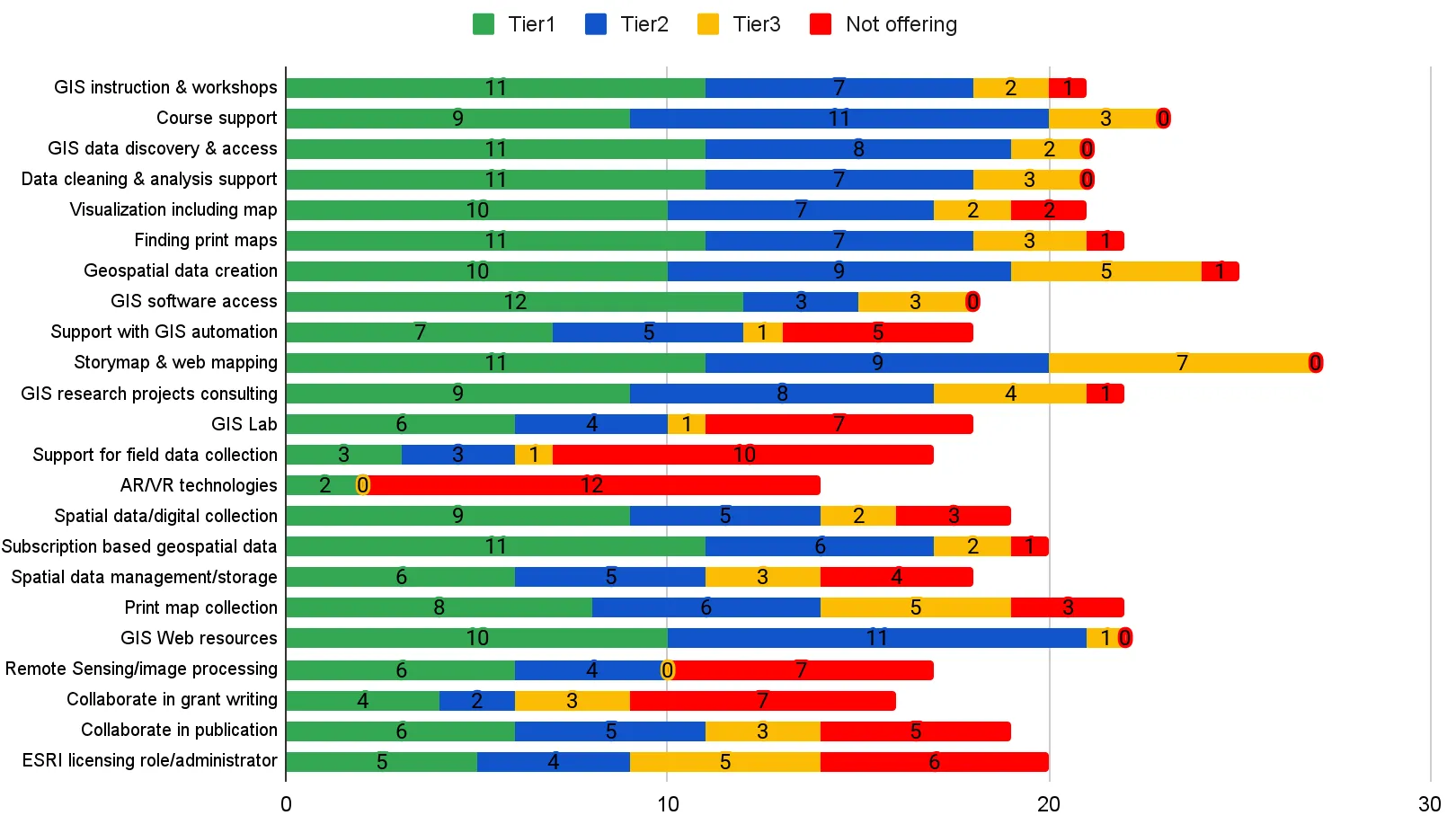
3.2: Results (Figure 1)
Section titled “3.2: Results (Figure 1)”- Most commonly offered services at Tier 1:
- GIS instruction/workshops (offered by 11 institutions)
- Data discovery (11): including finding print maps (11) and access to subscription databases (11)
- Geospatial analysis (11)
- Software access (12): including storymaps and web GIS (11)
- Tier 2 was also widely used, especially for:
- Course support (11)
- Data discovery (8)
- Data cleaning/analysis (7)
- Tier 3 was less common:
- Support with Storymap/ web mapping was the most frequent Tier 3 service (7 institutions)
- Other services like print map, spatial data creation and software licensing were popular Tier 3 services (5 institutions)
- “Not offering” responses were minimal, indicating most institutions offer at least basic support across service areas. Notable exceptions were support for field data collection (10 institutions not offering) and AR/VR (12 not offering).
3.3: Key Takeaways
Section titled “3.3: Key Takeaways”A: Tier Summary Figure
Section titled “A: Tier Summary Figure”A.1: Takeaways
Section titled “A.1: Takeaways”- Tier 1 Services Are Standardized: Nearly every institution provides basic workshops and help with data discovery, suggesting strong foundational support. Institutions are committed to maintaining Tier 1 services as foundational, but without additional investment, there’s a ceiling to expanding beyond that.
- Intermediate Support Is Widespread but Uneven: A significant portion of library GIS support is also in Tier 2—but lacks explicit naming or structure, which may limit internal resource advocacy or strategic planning.
- Advanced (Tier 3) Support is Limited: Most institutions offer limited advanced GIS support. Tier 3 is less common not because of lack of demand, but because it is resource-intensive and requires institutional commitment—either through additional hires, funding, or cross-departmental collaboration.
- Stands Out Across all Tiers: Services like course support, geospatial data creation, and storymap/web mapping stand out as being present across all three tiers, suggesting they are offered at varying levels of complexity and depth across institutions.
- Some respondents described GIS services as highly valued, yet they receive no added budget or staffing. The Tier figure reflects this reality: many institutions manage to offer services in multiple tiers despite minimal staffing (often just one GIS librarian). The service expansion in the figure likely reflects personal initiative rather than structural support.
A.2: Recommendations
Section titled “A.2: Recommendations”- Build Capacity for Tier 3 Services: Consider developing partnerships or external funding to support time-intensive engagements such as publication collaboration.
- Encourage Documentation of Tiered Models: Formalize these tiered approaches into library policies to better manage user expectations and workflows.
- Train Student Workers or GAs for Tier 1/Tier 2: Use student assistants strategically to expand support for basic and intermediate services.
- Assess Service Demand vs. Staff Time: Create logs or ticketing systems to track how much time each type of service request consumes to refine tiers.
A.3: Future Directions
Section titled “A.3: Future Directions”- Evaluate Advanced Services: Track publication outputs or faculty collaborations stemming from Tier 3 engagements.
- Explore AI Integration: Multiple respondents mentioned interest in GeoAI or AI-enhanced services, but noted limited capacity for exploring this topic.
- Promote Best Practices: Share documented tier models within the BTAA-GIN to inspire replication and refinement.
B: “How have your GIS services evolved over the past 5 years?”
Section titled “B: “How have your GIS services evolved over the past 5 years?””B.1: Takeaways
Section titled “B.1: Takeaways”One of the most prominent trends is the evolution from foundational support toward more integrated and strategic GIS services. Several institutions report an expansion in service scope, including increased collaborations with faculty, growth in data collections, and infrastructure development such as geoportals and ArcGIS Server implementations. For example, one institution highlighted a shift from basic services to a more collaborative and embedded model supporting public data sharing.
Another key takeaway is the impact of the COVID-19 pandemic. Nearly all institutions mentioned that the pandemic catalyzed a shift to remote or hybrid service models. Some services, like one-on-one consultations, remain primarily virtual, while course-based instruction has rebounded with increased demand for in-person sessions.
Staffing remains a critical factor in shaping GIS service delivery. Some institutions have expanded their teams with GIS specialists or graduate assistants, which has enabled them to take on more complex projects. Conversely, others have scaled back due to budget cuts and staffing losses, resulting in reduced workshop offerings or reliance on external support centers.
B.2: Recommendations
Section titled “B.2: Recommendations”- Institutionalize Hybrid Service Models: Maintain the flexibility of virtual consultations and asynchronous materials while reinvesting in high-impact, in-person instruction where possible.
- Develop Tiered Staffing Strategies: To support a range of GIS services from basic to advanced, libraries could explore hybrid teams that include full-time librarians and graduate assistants.
- Strengthen Faculty Partnerships: Continued collaboration with faculty can elevate GIS services from basic consultation to research and teaching partnerships.
- Assess Service Workflows and Referrals: For institutions with overlapping GIS units, clearly define roles and referral pathways to streamline user experience and reduce duplication.
B.3: Future Directions
Section titled “B.3: Future Directions”- Integrating AI Tools into GIS Services: As noted by a few respondents, libraries are starting to explore the use of GeoAI and generative AI. These technologies may reduce labor on data preparation tasks and open new avenues for instruction and research support.
- Expanded Role in Data Infrastructure: With the growth of geoportals and data repositories, libraries are poised to take on more responsibility in managing spatial data lifecycle tasks such as metadata curation, preservation, and FAIR compliance.
- Evaluation and Impact Assessment: There is an acknowledged need for more robust evaluation methods. Institutions should consider tracking GIS service impact through metrics such as instructional reach, consultation hours, research outputs supported, and student outcomes.
- Cross-Institutional Knowledge Sharing: The experiences documented in this survey could provide a strong foundation for developing shared service models, best practices documentation, and case studies across BTAA libraries.
C: “How do you measure the success/impact of your GIS services?”
Section titled “C: “How do you measure the success/impact of your GIS services?””C.1: Takeaways
Section titled “C.1: Takeaways”A clear theme is the lack of standardized, comprehensive assessment frameworks for evaluating GIS services in libraries. While many institutions track basic metrics like workshop attendance, consultations, and LibInsight data, very few report using formal impact evaluation strategies. A few institutions rely on qualitative feedback, anecdotal success stories, and faculty engagement as indirect indicators of success.
Some institutions do not systematically measure GIS service outcomes. Even among those that do collect data, the approaches are often fragmented, emphasizing convenience or visibility over deeper user impact or learning outcomes. This is understandable, as many respondents noted limited staffing and capacity—factors that can make comprehensive assessment difficult to prioritize.
However, a few respondents have started incorporating more nuanced and multi-dimensional indicators—such as repeat engagement, referral networks, and faculty collaborations—which point toward emerging models for measuring sustained impact.
C.2: Recommendations
Section titled “C.2: Recommendations”- Adopt a Mixed-Methods Evaluation Framework: Combine quantitative metrics (e.g., attendance, consultations, project output) with qualitative evidence (e.g., testimonials, faculty feedback) to capture both breadth and depth of GIS service impact.
- Indicate depth of support in metrics: Quantitative metrics can obscure the time investment and impact of support. Consider including data on time spent (including planning) for interactions and other metrics such as repeat engagement, collaborations, and referrals in reporting.
- Leverage Existing Library Tools: Platforms like LibInsight, LibCal, and internal project tracking systems can be adapted to systematically collect usage and outcome data across service tiers.
- Create a Centralized Dashboard: Develop a simple internal dashboard to monitor service usage trends, support transparency, and guide service planning.
C.3: Future Directions
Section titled “C.3: Future Directions”- Define Success Beyond Numbers: Future assessment should go beyond usage stats to include user learning outcomes, project success stories, and community building effects of GIS services.
- Develop BTAA-Wide Assessment Guidelines: A shared rubric or toolkit for evaluating GIS services across BTAA institutions would allow for benchmarking and collaborative improvement.
- Assess Emerging Technologies’ Effectiveness: As libraries explore new services like AI-assisted GIS and cloud platforms, they should include pilot evaluations and user feedback in the rollout.
D: “Are there any emerging trends or technologies you are considering for future GIS support?”
Section titled “D: “Are there any emerging trends or technologies you are considering for future GIS support?””D.1: Takeaways
Section titled “D.1: Takeaways”The dominant emerging trend across institutions is the growing interest in integrating artificial intelligence (AI)—particularly GeoAI and generative AI (GenAI)—into GIS workflows. Several respondents mentioned efforts to research or pilot AI-assisted spatial analysis, as well as plans to explore how these tools can meet evolving faculty and student needs.
There is also a clear interest in advanced raster data processing, such as drone imagery and platforms like Google Earth Engine. These services signal a shift toward more complex, data-intensive GIS work that extends beyond traditional vector mapping and data access.
In addition, some institutions are expanding support for cloud computing, high-performance computing (HPC), Jupyter Notebooks, and big geospatial data infrastructures. Others are experimenting with 3D scanning, PowerBI integration, and digital exhibits using web mapping, highlighting a desire to connect geospatial services with broader data visualization and storytelling trends in higher education.
Despite these innovations, several responses reveal capacity challenges, including staff bandwidth and version control issues, underscoring the tension between innovation and sustainability in GIS support services.
D.2: Recommendations
Section titled “D.2: Recommendations”- Pilot AI Applications with User Input: Initiate small-scale projects or workshops exploring GeoAI and GenAI with faculty and students to better understand needs, expectations, and feasibility.
- Train Staff in Emerging Technologies: Invest in professional development focused on tools like Google Earth Engine, machine learning, and cloud GIS platforms. Institutions with limited capacity should at minimum develop an awareness of these emerging trends in order to direct users to relevant resources.
D.3: Future Directions
Section titled “D.3: Future Directions”- Develop Use Cases for AI and Big Data in GIS: Collaborate with faculty to co-develop instructional or research use cases demonstrating the value and application of new technologies in real-world scenarios.
- Create Infrastructure for Scalable Services: As interest in AI and big data grows, institutions will need to invest in robust infrastructure (e.g., server capacity, cloud access, secure storage) to meet demand.
- Coordinate Knowledge Sharing Across BTAA: Encourage member institutions to share pilots, case studies, and implementation strategies through regular meetings, workshops, or a shared repository.
E: “Is there anything else you would like to share about GIS services at your library?”
Section titled “E: “Is there anything else you would like to share about GIS services at your library?””E.1: Takeaways
Section titled “E.1: Takeaways”- Recognition Doesn’t Always Bring Resources: Some respondents noted that while their GIS services are well-regarded, they do not necessarily receive proportional internal support or funding. Being perceived as “successful” can ironically reduce advocacy for additional staffing or budgets.
- Service Models Are Evolving but Not Always Formalized: A few libraries are in the process of building or expanding infrastructure, such as launching data portals. Others noted that while they do provide multi-tiered services, they don’t explicitly categorize them as such, and the “tier” model may not reflect the reality of how support is delivered.
- The Human Element Is Central: One respondent offered a reflective insight that GIS support is often shaped by the unique interpersonal and professional skills of individual staff members. The quality of service depends heavily on how well a person connects with patrons—a reminder that GIS services are not purely technical.
E.2: Recommendations
Section titled “E.2: Recommendations”- Make Service Models Explicit: Even if tiers aren’t officially adopted, defining internal expectations around levels of support can improve transparency and efficiency, particularly for new staff and collaborators.
E.3: Future Directions
Section titled “E.3: Future Directions”- Build Scalable and Context-Aware Services: Future GIS models must balance personalized support with scalable solutions that can serve diverse academic departments and projects, especially in resource-constrained settings.
- Support Staff as Individuals and Teams: Institutions should invest not only in tools and workflows but also in the professional growth of staff.
- Foster Peer Learning Across Institutions: Since much success depends on individual strengths and institutional contexts, spaces for open sharing (e.g., BTAA learning circles or case studies) can foster collective improvement.
Section 4: Non-Library GIS Service Providers
Section titled “Section 4: Non-Library GIS Service Providers”4.1: Types of Questions Asked
Section titled “4.1: Types of Questions Asked”This section collected responses from institutions based on GIS service providers outside the library. Most institutions (13 of 14 responding institutions) indicated there was a unit or departments at their institution outside the libraries that provides GIS services either free of charge or with fees for their campus communities.
4.2: Results
Section titled “4.2: Results”Institutions ranged from having one non-library unit to at least six or more units on their campuses that provide GIS services. Most libraries collaborate with other units offering GIS services to some degree in a mainly informal manner. There were a few instances of more formal arrangements made in the creation of a memorandum of understanding (MOU), such as for staffing. Other collaborations were also noted with specific units and departments based on faculty affiliation and committee involvement. Some examples of the collaborations related to forming connections with other units, supporting the GIS user communities, collaborating on campus programming, co-sponsoring events, sharing consultation requests depending on staff expertise, collaborating on documentation, collaborating on teaching classes and workshops, collaborating on student employee opportunities, collaborating on Esri licensing administration, and collaborating on grant proposals and research projects. This table is a summary of BTAA institutions and non-library GIS service providers.
Table 2. Non-library GIS service providers by BTAA institution survey responses
Indiana University
University of Iowa
University of Maryland
University of Michigan
Michigan State University
University of Minnesota
The Ohio State University
Penn State University
Purdue University
Rutgers University
University of Washington
4.3: Key Takeaways
Section titled “4.3: Key Takeaways”Some BTAA institutions have multiple non-library GIS service providers compared to others to manage collaborations, expectations, and outcomes. Some BTAA institutions have specific departmental services for user communities. A few BTAA institutions have more involvement with non-library GIS service providers than others; however, this is an area of possible expansion among BTAA institutions. Future directions may be to examine some of the institutional structures, context, and drivers for collaboration that foster units to work together in an informal nature compared to some institutions that may have less collaborations currently.